|
|
| Line 2: |
Line 2: |
| | | | |
| | <div class="map"> | | <div class="map"> |
| − | <googlemap version="0.9" lat="37.62137" lon="-122.391987" type="map" zoom="14" width="400">
| + | {{#display_map:37.62137, -122.391987|zoom=14|height=400|width=400|kml=http://maps.google.com/maps/ms?hl=en&ie=UTF8&vps=1&jsv=252b&msa=0&output=kml&msid=117455930571054512880.00048a7598b8104bc3dce}} |
| − | 37.615965, -122.392588
| + | </div> |
| − | Garage G/[[SFO Station|BART Station]]
| |
| − | 37.6166, -122.389912
| |
| − | International Terminal G
| |
| − | 37.617532, -122.386604
| |
| − | Terminal 3
| |
| − | 37.616729, -122.38462
| |
| − | Terminal 2
| |
| − | 37.615212, -122.385671
| |
| − | Terminal 1
| |
| − | 37.61449, -122.389131
| |
| − | International Terminal A
| |
| − | 37.613788, -122.391942
| |
| − | Garage A
| |
| − | 37.621701, -122.399502
| |
| − | West Field Road
| |
| − | 37.628168, -122.40123
| |
| − | Rental Car Center
| |
| − | 6#B20046FF
| |
| − | 37.628457, -122.401289
| |
| − | 37.626254, -122.400995
| |
| − | 37.623356, -122.399997
| |
| − | 37.622685, -122.399815
| |
| − | 37.620255, -122.399021
| |
| − | 37.61932, -122.398613
| |
| − | 37.617527, -122.397895
| |
| − | 37.616048, -122.397337
| |
| − | 37.615734, -122.397036
| |
| − | 37.615623, -122.396596
| |
| − | 37.615615, -122.39562
| |
| − | 37.615377, -122.395191
| |
| − | 37.615056, -122.395055
| |
| − | 37.613685, -122.39503
| |
| − | 37.613388, -122.394858
| |
| − | 37.613218, -122.394515
| |
| − | 37.613209, -122.394064
| |
| − | 37.61492, -122.387105
| |
| − | 37.615054, -122.386082
| |
| − | 37.615309, -122.385052
| |
| − | 37.616294, -122.384376
| |
| − | 37.617195, -122.384709
| |
| − | 37.617756, -122.385996
| |
| − | 37.617476, -122.387198
| |
| − | 37.617025, -122.388367
| |
| − | 37.615725, -122.393968
| |
| − | 37.615642, -122.394326
| |
| − | 37.615659, -122.395613
| |
| − | 6#B2FF0000
| |
| − | 37.615455, -122.394294
| |
| − | 37.616915, -122.388335
| |
| − | 37.617365, -122.387133
| |
| − | 37.617612, -122.3859
| |
| − | 37.617212, -122.384934
| |
| − | 37.616311, -122.384559
| |
| − | 37.615411, -122.385138
| |
| − | 37.615173, -122.386179
| |
| − | 37.615079, -122.387112
| |
| − | 37.613311, -122.394172
| |
| − | 37.613337, -122.394547
| |
| − | 37.613481, -122.394815
| |
| − | 37.61377, -122.394966
| |
| − | 37.614909, -122.394976
| |
| − | 37.615251, -122.394744
| |
| − | 37.615438, -122.394347
| |
| − | </googlemap></div>
| |
| − | | |
| | | | |
| | : [http://www.flysfo.com/web/page/atsfo/airtrain/ AirTrain's web site] | | : [http://www.flysfo.com/web/page/atsfo/airtrain/ AirTrain's web site] |
Revision as of 00:27, 3 July 2010
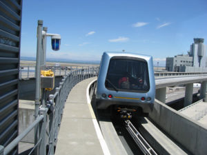
AirTrain is an automated internal transport system at San Francisco International Airport. It runs 24 hours, 7 days a week and is free for all riders.
Loading map...
{"minzoom":false,"maxzoom":false,"mappingservice":"leaflet","width":"400px","height":"400px","centre":false,"title":"","label":"","icon":"","lines":[],"polygons":[],"circles":[],"rectangles":[],"copycoords":false,"static":false,"zoom":14,"defzoom":14,"layers":["OpenStreetMap"],"image layers":[],"overlays":[],"resizable":false,"fullscreen":false,"scrollwheelzoom":true,"cluster":false,"clustermaxzoom":20,"clusterzoomonclick":true,"clustermaxradius":80,"clusterspiderfy":true,"geojson":"","clicktarget":"","imageLayers":[],"locations":[{"text":"","title":"","link":"","lat":37.62137,"lon":-122.391987,"icon":""}],"imageoverlays":null}
- AirTrain's web site
The system consists of Blue and Red lines. The Blue line serves all terminals (counter-clockwise) and continues to the Rental Car Center. The Red line serves the terminals (clockwise) only. Both lines stop at the BART's SFO Station by the International Terminal.
At the domestic terminals, the AirTrain stations are located on top of the short-term parking garage. Use the footbridge (Terminals 1 and 3) or underground tunnel (Terminal 2) to get from the stations to the terminals.
At the International Terminal, AirTrain stops by boarding areas A and G at the top level of the building.
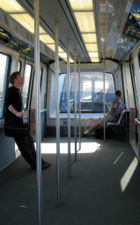
AirTrain allows luggage carts and bicycles onboard. AirTrain is the only form of transportation between the Rental Car Center and the terminals. AirTrain does not serve the long term parking lots.