Difference between revisions of "Larkspur Station"
m |
|||
| Line 4: | Line 4: | ||
|city=Larkspur | |city=Larkspur | ||
}} | }} | ||
| + | |||
| + | [[File:Larkspurrail.jpg|300px]] | ||
Larkspur is the southernmost station on the SMART line. It is also serve as a transfer point to [[Golden Gate Ferry]] to San Francisco at the nearby [[Larkspur Ferry Terminal|ferry terminal]]. The distance between the rail platform and ferry terminal is between 0.4 mile (shortest distance by using crosswalks at Sir Francis Drake) and 0.6 mile (longer distance via pedestrian overpass). | Larkspur is the southernmost station on the SMART line. It is also serve as a transfer point to [[Golden Gate Ferry]] to San Francisco at the nearby [[Larkspur Ferry Terminal|ferry terminal]]. The distance between the rail platform and ferry terminal is between 0.4 mile (shortest distance by using crosswalks at Sir Francis Drake) and 0.6 mile (longer distance via pedestrian overpass). | ||
| Line 21: | Line 23: | ||
|nstop note=''Terminus'' | |nstop note=''Terminus'' | ||
}} | }} | ||
| + | |||
| + | ==Bicycle== | ||
| + | Bike racks and [[BikeLink]] lockers are available at this station. | ||
| + | |||
| + | ==Parking== | ||
| + | $2 daily parking is available at the station. The parking lot in front of SMART station is also used as overflow parking for the ferry. | ||
| + | |||
| + | <onlyinclude>==Routes connecting SMART and ferry== | ||
| + | Map below shows two routes. The green route goes through the Marin Country Mart and should take 10-15 minutes on foot (no crossing at signalized intersection). The blue route is all Class 3 bike paths with no street crossing/signals. Both routes cross Sir Francis Drake via overpass. It is possible to cross Sir Francis Drake Blvd at signalized crossings for shorter distance but would suffer signal delays. | ||
| + | |||
| + | <div class=bigmap> | ||
| + | {{#display_map: 37.94777176231837,-122.5111204389417~Walking route through Marin Country Mart~ ~File:Pediconsmall.png; 37.94437215207162,-122.51138103241595~Biking route via Cal Park Tunnel Path overpass~ ~File:Mm_20_red.png; 37.947572687165355,-122.51268274457658~SMART station~ ~File:Rail20.png; 37.94453531252634,-122.50868088872636~Ferry Terminal~ ~File:Ferry20.png | ||
| + | |lines=37.94735407713367,-122.51277361996051:37.94671530631316,-122.51311694271442:37.94723139972481,-122.5126448739278:37.94718275173011,-122.51248930580493:37.94760789181205,-122.5121781695592:37.94737945864097,-122.51171682960864:37.94789131716668,-122.51091216690418:37.94737522839035,-122.51049910671588:37.9471637155495,-122.5104132760274:37.946863366269284,-122.51016114838:37.946867596549346,-122.50968265709696:37.94675760918823,-122.50968802151499:37.94672799717828,-122.51009035286722:37.946622239902354,-122.5101211982709:37.94594962006483,-122.51043194763292:37.945873474034855,-122.51038903228869:37.945590040896484,-122.5100135230266:37.94541275955318,-122.50969165794481:37.94522027775208,-122.50947708122362:37.94511451830607,-122.50943148367037:37.94465763575016,-122.50885212652315~Walking route through Marin Country Mart~ ~#005E1E~ ~3; 37.94736351036378,-122.5128381751008:37.94673320020115,-122.51317076901864:37.94641592793922,-122.51320295552682:37.94571792414061,-122.51351945619058:37.94508759986144,-122.51362674455117:37.94418652287814,-122.51355700711679:37.9441611402679,-122.51371793965768:37.94463917795514,-122.5138466856904:37.944795702893714,-122.51317076901864:37.94497760983583,-122.51270942906808:37.9452441238448,-122.51220517377328:37.944588413038616,-122.51165800313424:37.943568876873115,-122.5105153820939:37.94349272837605,-122.5103168986268:37.94370002132201,-122.50922255734872:37.94444034849835,-122.50896506528329~Biking route via Cal Park Tunnel Path overpass~ ~#1100FF~ ~3 | ||
| + | |service=leaflet|layers=HERE.Transit,HERE.Aerial | ||
| + | }} | ||
| + | </div></onlyinclude> | ||
[[Category:SMART stations]] | [[Category:SMART stations]] | ||
Revision as of 14:47, 14 December 2019
![]()
![]() City: Larkspur
City: Larkspur
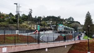
Larkspur is the southernmost station on the SMART line. It is also serve as a transfer point to Golden Gate Ferry to San Francisco at the nearby ferry terminal. The distance between the rail platform and ferry terminal is between 0.4 mile (shortest distance by using crosswalks at Sir Francis Drake) and 0.6 mile (longer distance via pedestrian overpass).
It is expected to take between 10 to 15 minutes to walk between these two locations, and faster with bicycles.
Points of interest
SMART
This station features center platform for SMART. Trains to Santa Rosa may depart on any track. Purchase and tag Clipper card at station or use mobile app to purchase fare before boarding the trains.
| Sonoma-Marin Area Rail Transit lines at Larkspur Station | ||||
|---|---|---|---|---|
| Next stop | Next stop | |||
| San Rafael Transit Center North to Sonoma County Airport
|
◀ | Sonoma-Marin Area Rail Transit | ▶ | Terminus
|
Bicycle
Bike racks and BikeLink lockers are available at this station.
Parking
$2 daily parking is available at the station. The parking lot in front of SMART station is also used as overflow parking for the ferry.
Routes connecting SMART and ferry
Map below shows two routes. The green route goes through the Marin Country Mart and should take 10-15 minutes on foot (no crossing at signalized intersection). The blue route is all Class 3 bike paths with no street crossing/signals. Both routes cross Sir Francis Drake via overpass. It is possible to cross Sir Francis Drake Blvd at signalized crossings for shorter distance but would suffer signal delays.

