Difference between revisions of "Map:Muni"
m |
m |
||
| Line 1: | Line 1: | ||
See '''[http://www.sfmta.com/maps/categories/system-maps Official Muni maps]''' here. | See '''[http://www.sfmta.com/maps/categories/system-maps Official Muni maps]''' here. | ||
===Interactive map=== | ===Interactive map=== | ||
| − | {{display point/sftmap|height= | + | <div class=bigmap>{{display point/sftmap|height=100%|width=100%|zoom=12|coordinates=37.762704, -122.435149|center=}}</div> |
<small>Map data: Open Street Map</small> | <small>Map data: Open Street Map</small> | ||
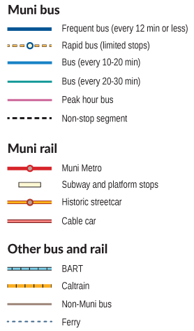
{{showhide|map legend}} | {{showhide|map legend}} | ||
Revision as of 18:15, 6 February 2015
See Official Muni maps here.
Interactive map
Map data: Open Street Map
Other Agency bus routes: G - Golden Gate Transit, S - SamTrans, P - PresidiGo Shuttle, W - WestCAT, ACT - AC Transit
| San Francisco Municipal Railway | |
|---|---|
| Muni Metro: | J Church • K Ingleside • L Taraval • M Ocean View • N Judah • S Shuttle • T Third Street |
| Heritage services: | |
| Bus routes: | Local • Rapid • Express • All-Nighter |
| Miscellaneous: | Fares • Maps |